
Name: Rebecca Wilks
Institution: The University of Edinburgh
PhD Project Title: Counting Elephants from Space: Applying Statistical Ecology and Satellite Data to Elephant Conservation
What is your background?
I’m currently a first year PhD researcher at the University of Edinburgh with the SENSE CDT program, and my project combines statistical ecology and machine learning to study elephants from space. My journey here was a slightly winding trail. Before coming to SENSE, I did a Mathematics BSc at The University of Leeds which I really enjoyed, before specializing with an MSc in Statistics at Imperial College London. I liked exploring the vast array of statistical methods out there, but wanted a break from ‘pure’ maths by that point. Still interested in more commercially focused problem-solving, I spent 1 year trying out various business strategy roles.
In my spare time, I’d been reading around the latest applications of ML / AI over traditional analytical methods, and decided to join an analytics consultancy to pursue this, where the focus was on building custom data-driven products. Over 4 years, I developed from a Data Analyst to an Analytics Engineer and built my coding skills up from basic R simulations, to pythonising code for production systems. Reading around initiatives to counter the environment crisis, I saw how state-of-the-art analytics will play a significant role, and wanted to apply my skills in the same way. I was drawn to my project, as it had a strongly statistical focus and would enable me to work within conservation research. The gaps in my skillset were that I didn’t have any background in Earth observation, or even applied science – I stopped physics/chemistry/biology/geography after GCSE, but I think a willingness to learn is what can get you by.
Tell us about your project and the area of environmental science you are most excited about
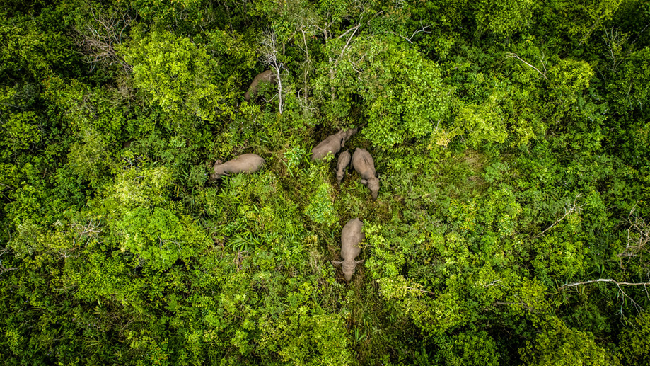
The aim of my project is to develop statistical methods which will make live satellite monitoring of African elephants more feasible. It has been shown (Duporge et al., 2021) that AI can detect elephants in images, but there’s a number of steps from this in order to take sample counts from AI and scale them up reliably for conservation efforts.
Elephants roam huge distances across protected and non-protected areas in Africa, and therefore monitoring exact population sizes with aerial surveys has being hugely time and effort intensive. With satellites able to cover much larger extents with ease, the hope is to be able to integrate satellite monitoring into current conservation efforts.
Integrating satellite data into conservation is just one example of the ‘AI for Conservation’ research area, which I’m hugely excited about for its potential to contribute to protecting many endangered species. There’s so many interesting applications where AI has made a difference, for example enabling unique identification of individuals and wildlife censuses, animal recognition in camera trap data, acoustic detection of animals, live poaching warning systems,… the list goes on!
In addition to the algorithmic developments, the creation of robust, open-source hardware (drones, camera traps, GPS trackers etc) are also vital to this area, and there are many pioneers creating innovative solutions to challenging problems.
For anyone interested in knowing more, nature communications recently released a great review paper – D Tuia et al., 2022.
Was using satellite data at the core of your PhD project important to you?
Yes and no (if that counts as an answer). Before coming across the SENSE CDT I wasn’t really aware of the analytical power of satellite data, in particular how crucial it will be to monitoring and countering large scale environmental changes. So in that sense, I wasn’t initially set on a project with this focus.
However, after seeing my project advertised and reading around what can be achieved via remote sensing, it was a skillset that I knew I wanted to learn. The fact that SENSE provides in-depth training across a range of environmental applications of satellite data was very important me, as I wanted to develop a solid foundational understanding given that I’d be new to the field.
Why did you decide to enter the space sector?
Pursuing a PhD was mainly a career decision, but it was a happy accident that such a cool project also unlocked pathways into the space sector! I’ve always found the space sector interesting, but felt that I didn’t have the scientific grounding to pursue a career there, so it wasn’t on my radar.
The satellite-space sector is a hugely exciting place to be right now, with new launch ports opening in UK, continuing democratization of higher resolution data and a highly active research community.
What does equity, diversity and inclusion mean to you?
It’s a really important issue – everyone should feel able to be true to themselves where they work, regardless of their personal beliefs, background or circumstances.
I believe that each person plays a part in creating a culture of openness, acceptance and encouragement where others can thrive. Culture is vital, but some barriers can only be overcome with proper institutional support. In SENSE’s case, we have a dedicated D&I officer and policies to ensure equal opportunities for all. There’s a nice camaraderie across the cohorts too, which is lovely!
Any tips for those interested in applying for PhDs?
- It’s good to think about if the change from a lesson based style if you’re coming from undergraduate, or structured teamwork if coming from industry, to a personal research project is something you’re sure you would enjoy.
- Don’t shy away from being bold in explaining that you have the skills and enthusiasm to do your chosen project. This is something that I’ve found hard in the past and it can feel unnatural, but it helps so much during the interview process.
- Trying out coding tutorials can be helpful to understand the type of data you may work with, and what your bread-and-butter of satellite based analysis will consist of.
Good luck with your application! 🙂
You can find Rebecca on Twitter @Beckycwilks and on Linkedin.